Explore More
Live WILD - Help preserve the lands you love...
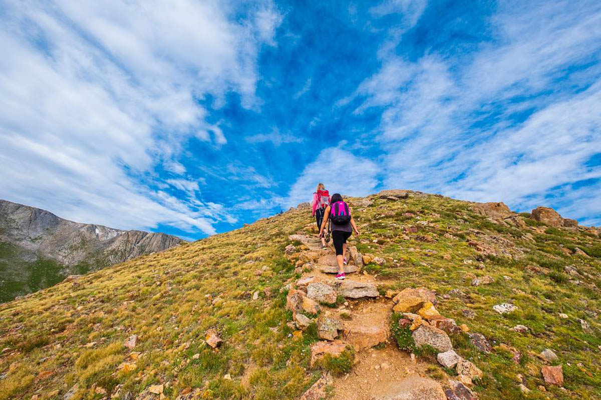
Explore Clear Creek County by Foot
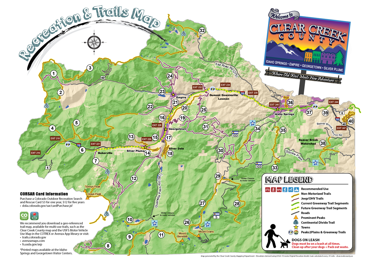
Clear Creek County is made up of more than 75% public land offering an unparalleled amount of outdoor recreational opportunity ~ including hiking! Below you will find a collection of trails with information on difficulty, length, trip type and directions. And be sure to check out the Clear Creek County Recreation and Trails Map highlighting 40 recreational areas in Clear Creek County.
Please print this card, fill it out, leave it face down on your dashboard, as the information provided will assist local authorities in case of emergency.
Easy Trails
Bakerville Loveland Trail – BLT (Clear Creek Greenway Segment)
With a slight uphill grade, running parallel to I-70 from Bakerville to Loveland Valley Ski Area, this paved, multi-use recreational path is perfect for year-round use. Snowcat grooming during winter months provides an improved experience for fat bikes, cross-country skiers and snow-shoers.
- Level: Easy
- Distance: 5 miles, one way
- Elevation start/high/gain: 9,776’/10,682’/1,218’
- Getting there:The East Trailhead is located on the frontage road at Bakerville, just south of I-70 at exit #221. The West Trailhead on the frontage road on the east side of the Loveland Valley Ski Area at I-70 exit #216.
Silver Dollar Lake Trail
The Silver Dollar Lake Trail is great for hiking and wildlife viewing near high-alpine lakes. Silver Dollar Lake is a 1.6 mi hike from the trailhead, while Murray Lake is another .5 mi beyond.
- Level: Easy
- Distance: 4.2 miles, roundtrip
- Elevation start/high/gain: 11,199’/12,208’/1,148’
- Getting there: Follow Guanella Pass Rd, to Silver Dollar Lake Rd,, a rough dirt road for .7 mi to the Silver Dollar Lake Trailhead. Park in the lot on the right. Silver Dollar Lake Rd. is extremely difficult to navigate in winter conditions. All winter hikers should park at the Guanella Pass Rd. intersection and hike .7 mi to the Silver Dollar Lake Trailhead.
Silver Plume to Georgetown Express Trail (Clear Creek Greenway Segment)
This segment of the Clear Creek Greenway is an asphalt path running between historic Silver Plume and the Georgetown Loop Railroad stations. With a view of the nearby train and its tracks, including an excellent overlook area, this 1.5-mile trail is perfect for biking and hiking, year-round.
- Level: Easy
- Distance: 1.5 miles, one way
- Elevation start/high/gain: 8,687’/9,114’/541’
- Getting there: Access the East Trailhead at the upper (back) corner of the Georgetown Loop Railroad parking lot, (the approximate address is: 646 Loop Dr., Georgetown, 80444). Access the West Trailhead at the Georgetown Loop Railroad’s Silver Plume Depot (the approximate address is 825 Railroad Ave., Silver Plume, 80476). For easier parking, visitors are encouraged to park in Silver Plume and hike/ride to Trailhead while seeing sights along the way.
Silverdale Trail
This beginner-oriented (non-motorized) trail network, with a few intermediate sections, is open year-round. Here, three, well-marked, color-coded “loops” let hikers easily navigate between six short trails within Silver Dale:
- Sporting Times
- Railbed
- Clear Branch
- Chicago Road
- Highline Trail
- Anna Trail
While you hike, soak up some history. Silver Dale is an old mining area which has markers with QR codes that provide captivating information on specific sites along each trail.
- Level: Easy/Intermediate
- Distance: 4.2 mile trail network
- Elevation start/high/gain: 9,266’/10,127’
- Getting there: TH and parking located on Guanella Pass Rd, 2 mi up from
- Georgetown (the approximate address is 1380 Co Rd 381, Georgetown, 80444).
PAW Education Research Trail (PERT)
PERT opened in 2013 as an ADA accessible trail showcasing the history of the wagon road over Berthoud Pass. The trail is 481-feet long with steep grades. The trail is also enhanced for the visually impaired with gravel sections level with the trail, which provides a different texture for impared hikers to roam on.
- Level: Easy (ADA Accessible)
- Distance: 0.2 miles, one way
- Elevation start/high/gain: 8,629’/8,641’/14’
- Getting there: Access this trail less than one mile West from Empire off US40, just north of West Park Ave.
Tom Bennhoff Lake Trail
Named after former Georgetown Mayor Tom Bennhoff, this wide, fairly flat gravel walking path loops around Georgetown Lake. Hikers, bikers, fishermen, snowshoers and others looking for an easy stroll around the lake will thoroughly enjoy this trail any time of year. The short Purdy and Dunbarton connector trails on the backside of the trail provide access to Silver Creek Trail higher up on the ridge side.
- Level: Easy
- Distance: 1.3 miles roundtrip (loop)
- Elevation start/high/gain: 8,468’/8,530’/227’
- Getting there: The trailhead and its parking lot are located just near Georgetown Lake (the approximate address 2001 22nd St., Georgetown, 80444).
St. Mary’s Glacier Trail
This is a fantastic out and back trail with a moderate uphill grade. The trail starts wide, but narrows into numerous side trails that branch off through wooded areas. Hikers will find St. Mary’s Lake about .5 mi up the trail. From there, take the bridge across and continue up the rocky hill to the glacier, or continue another mile to Kingston Peak Trail for great high-altitude views. The St. Mary’s Glacier Trail is enjoyable year round, and is an exceptional favorite for snowshoeing.
- Level: Easy
- Distance: 3.9 mi round trip
Elevation start/high/gain: 10,540’/11,653’/1,147’ - Getting there: The trailhead and two paid parking lots are located 9 mi up Fall River Rd off I-70 exit #238 (the approximate address is 9054 Fall River Rd, Idaho Springs, 80452).
- Parking is $20. Self-pay fee station. Cash or check only. $20 fee per vehicle per calendar day. Deposit fee in provided white envelope into fee slot. Yellow slip goes on dash.
Clear Creek Greenway Trail
Various segments make-up this “trail” that will become part of the P2P (Peaks-to-Plains) trail system crossing Colorado. But for now, it remains a patchwork of interconnected 6-8ft wide concrete and asphalt paths, interspersed with bike lanes along frontage roads running the length of Clear Creek County from Hwy 6 & I-70 east of Idaho Springs to Loveland Valley Ski Area. This is a great multi-use recreational path and provides access for fishing and wildlife viewing. Construction is ongoing. www.ccgreenway.com.
- Level: Easy/Intermediate
- Distance: 30 miles one way
- Elevation start/high/gain:: 7,231’/10,682’/5,657’
- Getting There: East TH on the US 40 Frontage Rd, across Hwy 6 from Two Bears Tap & Grill at I-70 exit #244, approx. address 33295 US-6, Idaho Springs, 80452. West TH on the Frontage Rd adjacent to the Loveland Valley Ski Area at I-70 exit #216. Several parking areas with trail access at various locations along the Greenway.
Scott Lancaster Memorial Trail (Clear Creek Greenway Segment)
This paved, multi-use recreational path features bike lane sections along frontage roads parallel to US HWY 6 and I-70, just west of Floyd Hill, and across the Scott Lancaster Memorial Bridge in Idaho Springs.
- Level: Easy
- Distance: 4 mi, one way
- Elevation start/high/gain: 7,231’/7,561’/878’
- Getting there: Two parking and trailhead locations available at the Shelly/Quinn Ball Fields (101 E. Idaho Springs Rd, 80452) and Game Check Station (1335 E. Idaho Springs Rd, 80452). Find additional parking in Idaho Springs.
Echo Lake Trail
Enjoyed year round, this trail offers an easy, relaxing walk around the south side of Echo Lake with beautiful scenery. This trail also provides access to Chicago Lakes Trail #52 for those interested in continuing their journey to Summit Lake. Bicycles are not allowed on this path. Great for snowshoeing.
- Level: Easy
- Distance: 0.75 miles one way
- Elevation start/high/gain: 10,600’/10,661’/90’
- Getting there: I-70 exit #240 up Hwy 103 12.5 mi from Idaho Springs, approx. address 12334 Squaw Pass Rd, Idaho Springs, 80452. Parking at Echo Lake picnic area or near the gate for Mt Blue Sky.
Intermediate Trails
Butler Gulch Trail
This trail starts out as a narrow, closed road winding through the forest at a slight grade. Halfway up, the grade becomes steeper through spruce and fir forest until ending at an open bowl. Great for viewing wildflowers in the summer and backcountry skiing, snowshoeing and fat biking in the winter.
- Level: Intermediate
- Distance: 4.9 miles roundtrip
- Elevation start/high/gain: 10,516’/11,926’/1,573’
- Getting there: Butler Gulch TH is located on Jones Pass Rd (FSR 144.1), west of Berthoud Falls, approx. 0.5 mi up Road 202 from Henderson Mine, approx. address 1746 Co Rd 202, Empire, 80438.
Herman Gulch (Trail #98)
A former sawmill road up Herman Gulch at a moderate grade, but steepens significantly to Herman Lake above tree line. Winds through forest, wildflower meadows and creeks, with occasional bighorn sheep or mountain goat sightings. Heavily trafficked during the summer weekends. A portion of the Continental Divide Trail overlaps most of the Herman Gulch Trail.
- Level: Intermediate
- Distance: 6.4 miles roundtrip
- Elevation start/high/gain: 10,294’/12,012’/1,853’
- Getting there: TH with large dirt parking lot north side of I-70 at exit #218, approx. address Watrous Way, Silver Plume, 80435.
Geneva Basin / Iron Fens
This location is registered as a Colorado State Natural Area with large areas of peat-forming wetlands, which reddish in color due to the iron in the ground water draining from surrounding calcareous rocks. Hike the dirt roads throughout the area, but please stay on the trail as the Iron Fens are environmentally sensitive. The OHV trails are a network of old mining roads near the Iron Fens. Many old mines, and historic structures line the area, including remnants of the Sill Mine. Geneva Basin (aka Upper Geneva Creek) is a diverse trail, offering amazing views up to what was Geneva City.
- Level: Intermediate
- Distance: 4 mile trail network
- Elevation start/high/gain: 1,688’
- Getting there: Follow Guanella Pass Rd to top and turn on Geneva Creek Rd (FSR 119), approx. address is 6118 Co Rd 62, Grant, 80448. Follow Geneva Creek Rd (rough dirt road) for 5 mi to the fork, past campsite #42. Turn right at the fork to enjoy Geneva Basin OHV trails or go left and follow the road a short way to the locked gate, this is the (non-motorized) Iron Fen Trailhead.
Mt Bierstadt (Trail #711)
This 14er offers fantastic views of the surrounding area and is within the Mt. Evans Wilderness Area. Bikes are not allowed. Mt. Evans can also be reached via the Sawtooth connector for those up for the challenge. Winter closure at the Naylor Lake intersection and approximately 0.8 mi north of the summit, reopening Memorial Day weekend, weather permitting. Non-motorized use such as bicycling, snowshoeing and backcountry skiing is permissible year-round. Weekend usage is very heavy, so plan accordingly.
- Level: Intermediate
- Distance: 7.2 miles roundtrip
- Elevation start/high/gain: 11,630’/14,061’/2,697’
- Getting there: TH with asphalt parking lot near the summit of Guanella Pass Rd. Limited Parking.
7:30 Mine Trail
Narrow mining road up to the 7:30 Mine. Grade varies from 10-15%. Trail is lined with historical markers and artifacts. Griffin Monument, approx. 2 mi up offers excellent views of the area, continuing .25 mi to the 7:30 Mine.
- Level: Intermediate
- Distance: 4.5 MI RT
- Elevation start/high/gain: 9,148’/10,586’/1,667’
- Getting there: TH with limited parking at the north end of Silver St., approx. address 805 Silver St., Silver Plume, 80476. Additional parking in town.
Argentine Central RR Grade Trail
Argentine Central RR Grade combines two segments; a (non-motorized) 2.4 mi segment winding up to Pavillion Point from main Trailhead in Silver Plume where the 4×4 road continues down .8 mi to Creek Rd. The Argentine Central RR Grade represents remnants of an old railroad from Silver Plume to Pavilion Point to Waldorf and Mt McClellan. Grade maxes out at 7.5% making it perfect for hiking, biking, and snowshoeing. It’s also great as an up & down or as a connector between Silver Plume and Silver Dale.
- Level: Intermediate
- Distance: 3.2 miles one way
- Elevation gain: 1,433’
- Getting there: The main trailhead in Silver Plume is a half mile west of the Loop Railroad on Frontage Rd (the approximate address is: 120 Mountain St., Silver Plume, 80476). For the lower trailhead and 4×4 segment on Leavenworth Creek Rd go 1.2 mi up Guanella Pass Rd to Pavilion Point (which has limited parking).
Rutherford Trail
Excellent hiking and snowshoeing from Georgetown to Silver Dale and connects to Sporting Times Trail. Trail runs adjacent to S. Clear Creek with grades varying from 5-12%. Begins as a dirt road through a gate and heads up along the creek. Narrow trail begins across the last bridge, about .3 mi up. The trail continues along the creek and connects to Sporting Times Trail in Silver Dale. A kiosk sign providing information can be found at the TH. QR code signs along the way mark historic locations.
- Level: Intermediate
- Distance: .93 miles one way
- Elevation start/high/gain:: 8,553’/9,234’/798’
- Getting there: Lower TH and parking lot at the end of 3rd St. in the southwest corner of Georgetown. Upper TH located in Silver Dale, along the Sporting Times Trail.
Silver Creek Trail
Running from Saxon Mtn Rd to Spring Creek (Silver City Jeep Rd) road above Lawson. The grade/elevation change is minimal, but technical sections, obstacles, and narrow segments with steep drops keep your heart rate up while biking this trail. Old mines along the way add to the experience. Fairly easy for hiking, but significant exposure makes it intermediate for mountain biking. Hikers access the Silver Creek Trail via Purdy Trail off Tom Bennhoff Lake Trail or access trail on the frontage road.
- Level: Intermediate
- Distance: 4.6 miles one way
- Elevation start/high/gain: 8,618’/9,009’/1,778’
- Getting there: West TH located just off the last driveway on Saxon Mtn Rd in Georgetown approx. address 350 Saxon Mtn Rd, Georgetown, 80444. Trail can also be accessed via the Purdy and Dunbarton connector trails on Tom Bennhoff Lake Trail, or via a .4 mi access trail (w/small parking lot) on frontage road, approx. address 849 Alvarado Rd, Georgetown, 80444.
Chicago Lakes (Trail #52)
This trail climbs its way up at a steady grade from Echo Lake, then alongside Chicago Creek through the Mt Blue Sky Wilderness past Idaho Springs Reservoir and Chicago Lakes, up a rocky section to Summit Lake. Bikes are not allowed on this trail. The upper TH intersects with the Mt Blue Sky West Ridge via Mt Spalding Trail #51. Users can hike this as an up & down, shuttle from Summit Lake, or continue to the top of Mt Blue Sky (Formerly Mt Evans).
- Level: Intermediate
- Distance: 5.4 miles one way
- Elevation start/high/gain: 10,600’/12,865’/3,024’
- Getting there: The lower TH is on the backside of Echo Lake Trail, park at Echo Lake off of Hwy 103. The upper TH is at Summit Lake, 9 mi up Mt Blue Sky Rd.
Resthouse Meadows (Trail #57)
Climbs through trees and across Vance Creek where 700 acres of forest burned in the 1962 Lincoln Lake Fire. Elk now enjoy grazing the meadow. Out & back hikers take the right fork to Lincoln Lake Trail (Trail #45) midway through the meadow for the .5 mi walk to Lincoln Lake before heading back down to Echo Lake for a 11+ mi hike. Long distance hikers – continue last mile of steep terrain to Summit Lake Flats Trail (Trail #82) to Summit Lake, or beyond the intersection to trail’s end at Beaver Meadows Trail (Trail #44).
- Level: Intermediate
- Distance: 6.4 mile one way
- Elevation start/high/gain: 10,655’/11,444’/1,754’
Getting there: From I-70 exit #240, travel 14 mi south on Hwy 103 to Echo Lake Campground. Trail begins on campground loop (FSR 191.1). Follow “TRAIL” signs past restrooms and camp sites.
Chief Mountain (Trail #58)
- Level: Intermediate
- Distance: 2.9 mile round trip
- Elevation start/high/gain: 10,722’/11,707’/1,039’
- Getting there: Parking in a pullout on the north side of Hwy 103, .5 mi west of Echo Mountain Ski Resort near mile marker 18, TH across the Hwy.
About: Users encounter a consistent uphill grade through spruce and fir forest to tree line where the alpine tundra begins. This fairly arduous, hiking trail, with a steep section prior to the summit where you will be rewarded with incredible 360 degree views of the surrounding area, including Bear Creek Basin, Mt Blue Sky, Mt Goliath, Rogers Peak and Roslin Peak.
Barbour Fork Area (Including Trail #48)
Mix of single track and OHV roads. Hikers can explore the area via Trail #48 (non-motorized) combined with OHV roads crossing through groves of aspen and conifer trees. All will appreciate fantastic overlooks and ruins along the way.
- Level: Intermediate
- Distance: 8 mile trail network
- Elevation start/high/gain: 8,692’/10,572’/2,542’
- Getting there: TH w/large dirt parking lot located 3 mi past Indian Hot Springs on Soda Creek Rd, approx. address 2930 Soda Creek Rd, Idaho Springs, 80452. Trail #48 is located .5 mi up FSR 194.2.
Beaver Brook Watershed Trail
Network of old wagon roads for hikers, bikers and equestrians. Main trail runs from Old Squaw Pass Rd to Beaver Brook Reservoir where it bears left towards the upper TH at Witter Gulch Rd North Beaver Brook Trail splits to the right up an old wagon trail to Pat Creek Open Space.
Level: Intermediate
Distance: 12 mile trail network
Elevation Start/High: 8,543’/9,183’
Getting there: Three access points; upper TH w/ large parking area on Hwy 103 at Witter Gulch Rd (Road 475). Lower TH (w/limited parking) on Old Squaw Pass Rd at Hwy 103, and Pat Creek Open Space TH (w/limited parking) along Beaver Brook Canyon Rd near Floyd Hill.
Floyd Hill Open Space Trail
1.3 mile “necktie loop” route created by combining a new single track with old wagon roads. Provides fantastic views of the surrounding area and access higher up on Floyd Hill, where hikers can continue exploring the area or head back down the wagon road portion of the loop.
- Level: Easy/Intermediate
- Distance: 1.3 mile trail network
- Elevation start/high/gain: 7,931’/8,335’/466’
- Getting there: TH and dirt parking lot on US40 at the bottom of Floyd Hill, on north side of I-70 at exit #247. From Denver exit #248 and continue 1.3 mi west on US40 to the trailhead. Approx. address 37899 US40, Evergreen, 80439.
Hard Trails
Continental Divide Trail (CDT)
The Continental Divide Trail (CDT) runs 3,100 miles between Mexico and Canada, crossing 5 states as it follows the Rocky Mountains. The CDT section through Clear Creek County travels from James Peak to Argentine Pass (51.4 mi). Several remote high elevation sections of the CDT make it a primitive, adventurous route for skilled hikers, with one of the best routes being between Berthoud Pass and Argentine Pass (35 mi). Remember, not all sections are open to mountain bikes so please research trail openings before your trip.
- Level: Intermediate/Advanced
- Distance: 35 miles one way
- Elevation gain: 11,548’
- Getting there: Access the Argentine Pass Trailhead by taking Hwy 6 east towards Keystone, right on Montezuma Rd, left on Peru Creek Rd (Co Rd 260). The Berthoud Falls Trailhead (and parking lot) is located 6 mi north of Berthoud Falls on US 40, west of Empire.
Watrous Gulch Trail
This steep, rocky trail winds upwards a little over 2 mi from the lower TH to a spot high up on Woods Mtn, not quite to the top. At the 1.3 mile mark, it intersects with the west end of Bard Creek Trail. Watrous Gulch is a great fitness challenge trail with awesome views.
- Level: Advanced
- Distance: 2.1 miles one way
- Elevation start/high/gain: 10,294’/11,759’/1,558’
- Getting there: TH with large dirt parking lot north side of I-70 at exit #218, approx. address Watrous Way, Silver Plume, 80435.
Grays & Torreys Peaks (Trail #54)
Grays & Torreys 14’ers are situated very close together on the continental divide. They can easily be combined into a one day hike. Bikes are not allowed. Grays is the highest point on the Continental Divide, providing fantastic views of the surrounding area. Weekend traffic is very heavy, so plan accordingly.
- Level: Advanced
- Distance: 8 Miles Roundtrip
- Elevation start/high/gain: 11,236’/14,260’/3,765’
- Getting there: I-70 at Bakerville exit# 221. Overflow parking at the bottom of Stevens Gulch Rd, ¼ mi south of the exit. TH and upper parking lot 3 mi up Stevens Gulch Rd.
Bard Creek (Trail #83)
Single track from Bard Creek Rd to Watrous Gulch Trail. This fairly long, mixed level trail is an all-day hike if you’re planning to travel from one end to the other. The eastern half runs along Bard Creek and offers fantastic views above the treeline. The Watrous Gulch Trail segment is advanced with steep rock obstacles. Route finding can be challenging above tree line, keep an eye out for rock cairns and prepare for rapidly changing weather conditions.
- Level: Intermediate/Advanced
- Distance: 9.8 miles one way
- Elevation start/high/gain: 10,130’/12,037’/3,647’
- Getting there: East TH (w/limited parking) at the end of Bard Creek Rd (FSR 777.1), 4 mi west of Empire. Additional parking in pull-outs along FSR 777.1 or in town. West TH at intersection with Watrous Gulch Trail, 1.5 mi from large dirt parking lot at Herman/Watrous Gulch TH off I-70 exit #218.
Mt. Blue Sky (West Ridge via Mt Spalding + Trail #51)
This steep and rocky trail at high altitude is not for beginners. Hike from Summit Lake as an up & down, or catch a ride back down Mt Blue Sky Rd. You are encouraged to visit the interpretive center and continue the short .3 mi walk up Trail #51 to the summit of Mt Blue Sky (Formerly Mt Evans) at 14,271’ for amazing views and wildlife such as marmots and mountain goats. Those who prefer a paved route to the top can traverse the 14.4 mi route from the Forest Service gate on Hwy 103/Hwy 5 intersection to the top of Mt Blue Sky. This route is closed to vehicles Memorial Day through Labor Day, weather permitting. Weekend usage is very heavy, so plan accordingly.
- Level: Advanced
- Distance: 2.75 miles one way
- Elevation start/high/gain: 12,248’/14,246’/2,000’
- Getting there: Mt Blue Sky lower TH and parking area at Summit Lake, 9 mi up Mt Blue Sky Rd from the gate at Hwy 103. The upper TH is at the top of Mt Blue Sky. Reservations + Fees apply for vehicles.